Aerial Imagery Pile burn detection using Deep Learning: the FLAME dataset
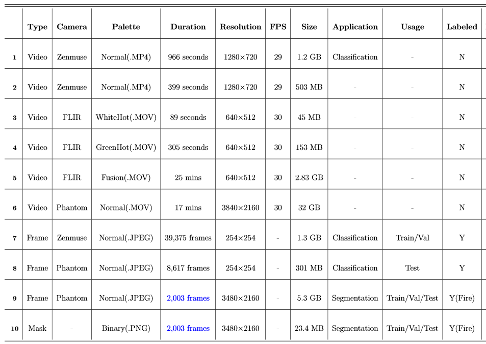
Wildfires are one of the costliest and deadliest natural disasters in the US, causing damage to millions of hectares of forest resources and threatening the lives of people and animals. Of particular importance are risks to firefighters and operational forces, which highlights the need for leveraging technology to minimize danger to people and property. FLAME (Fire Luminosity Airborne-based Machine learning Evaluation) offers a dataset of aerial images of fires along with methods for fire detection and segmentation which can help firefighters and researchers to develop optimal fire management strategies. This paper provides a fire image dataset collected by drones during a prescribed burning piled detritus in an Arizona pine forest. The dataset includes video recordings and thermal heatmaps captured by infrared cameras. The captured videos and images are annotated and labeled frame-wise to help researchers easily apply their fire detection and modeling algorithms. The paper also highlights solutions to two machine learning problems: (1) Binary classification of video frames based on the presence [and absence] of fire flames. An Artificial Neural Network (ANN) method is developed that achieved a 76% classification accuracy. (2) Fire detection using segmentation methods to precisely determine fire borders. A deep learning method is designed based on the U-Net up-sampling and down-sampling approach to extract a fire mask from the video frames. Our FLAME method approached a precision of 92% and a recall of 84%. Future research will expand the technique for free burning broadcast fire using thermal images.
PDF Abstract

Datasets
Introduced in the Paper:
 FLAME
FLAME
