Search Results for author:
Found 13 papers, 5 papers with code
Exploring DINO: Emergent Properties and Limitations for Synthetic Aperture Radar Imagery
We observe a small improvement in model performance with pre-training compared to training from scratch and discuss the limitations and opportunities of SSL for remote sensing and land cover segmentation.

Exploring Generalisability of Self-Distillation with No Labels for SAR-Based Vegetation Prediction
In this work we pre-train a DINO-ViT based model using two Synthetic Aperture Radar datasets (S1GRD or GSSIC) across three regions (China, Conus, Europe).
Large Scale Masked Autoencoding for Reducing Label Requirements on SAR Data
Satellite-based remote sensing is instrumental in the monitoring and mitigation of the effects of anthropogenic climate change.
Fewshot learning on global multimodal embeddings for earth observation tasks
In this work we pretrain a CLIP/ViT based model using three different modalities of satellite imagery across five AOIs covering over ~10\% of Earth's total landmass, namely Sentinel 2 RGB optical imagery, Sentinel 1 SAR radar amplitude and interferometric coherence.
Enhancing Self-Supervised Learning for Remote Sensing with Elevation Data: A Case Study with Scarce And High Level Semantic Labels
We assess the performance of our approach on a binary semantic segmentation task and a binary image classification task, both derived from a dataset created for the northwest of Colombia.
Deep learning based landslide density estimation on SAR data for rapid response
Since such data might not be available during other events or regions, we aimed to produce a landslide density map using only elevation and SAR data to be useful to decision-makers in rapid response scenarios.
SAR-based landslide classification pretraining leads to better segmentation
In the case of landslides, rapid assessment involves determining the extent of the area affected and measuring the size and location of individual landslides.

Deep Learning for Rapid Landslide Detection using Synthetic Aperture Radar (SAR) Datacubes
With climate change predicted to increase the likelihood of landslide events, there is a growing need for rapid landslide detection technologies that help inform emergency responses.
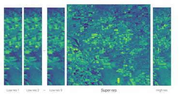
Open High-Resolution Satellite Imagery: The WorldStrat Dataset -- With Application to Super-Resolution
We hereby hope to foster broad-spectrum applications of ML to satellite imagery, and possibly develop from free public low-resolution Sentinel2 imagery the same power of analysis allowed by costly private high-resolution imagery.
Multi-Spectral Multi-Image Super-Resolution of Sentinel-2 with Radiometric Consistency Losses and Its Effect on Building Delineation
High resolution remote sensing imagery is used in broad range of tasks, including detection and classification of objects.

RainBench: Towards Global Precipitation Forecasting from Satellite Imagery
Extreme precipitation events, such as violent rainfall and hail storms, routinely ravage economies and livelihoods around the developing world.
Pix2Streams: Dynamic Hydrology Maps from Satellite-LiDAR Fusion
A complete map of our daily waters can give us an early warning for where droughts are born: the receding tips of the flowing network.

Counting Cows: Tracking Illegal Cattle Ranching From High-Resolution Satellite Imagery
Cattle farming is responsible for 8. 8\% of greenhouse gas emissions worldwide.
