Search Results for author:
Found 50 papers, 17 papers with code
Learning from Unlabelled Data with Transformers: Domain Adaptation for Semantic Segmentation of High Resolution Aerial Images
In this paper, we develop a new model for semantic segmentation of unlabelled images, the Non-annotated Earth Observation Semantic Segmentation (NEOS) model.

A Semantic Segmentation-guided Approach for Ground-to-Aerial Image Matching
Nowadays the accurate geo-localization of ground-view images has an important role across domains as diverse as journalism, forensics analysis, transports, and Earth Observation.

Neural Plasticity-Inspired Foundation Model for Observing the Earth Crossing Modalities
The development of foundation models has revolutionized our ability to interpret the Earth's surface using satellite observational data.
A Hybrid MLP-Quantum approach in Graph Convolutional Neural Networks for Oceanic Nino Index (ONI) prediction
This paper explores an innovative fusion of Quantum Computing (QC) and Artificial Intelligence (AI) through the development of a Hybrid Quantum Graph Convolutional Neural Network (HQGCNN), combining a Graph Convolutional Neural Network (GCNN) with a Quantum Multilayer Perceptron (MLP).
PhilEO Bench: Evaluating Geo-Spatial Foundation Models
Massive amounts of unlabelled data are captured by Earth Observation (EO) satellites, with the Sentinel-2 constellation generating 1. 6 TB of data daily.
The curse of language biases in remote sensing VQA: the role of spatial attributes, language diversity, and the need for clear evaluation
While new, improved and less-biased datasets appear as a necessity for the development of the promising field of RSVQA, we demonstrate that more informed, relative evaluation metrics remain much needed to transparently communicate results of future RSVQA methods.

Estimating optical vegetation indices with Sentinel-1 SAR data and AutoML
Time series of four VIs (LAI, FAPAR, EVI and NDVI) were estimated using multitemporal Sentinel-1 SAR and ancillary data.
Quantum Machine Learning for Remote Sensing: Exploring potential and challenges
In this paper, we investigate the application of QML in the field of remote sensing.
Diffusion Models for Earth Observation Use-cases: from cloud removal to urban change detection
The advancements in the state of the art of generative Artificial Intelligence (AI) brought by diffusion models can be highly beneficial in novel contexts involving Earth observation data.

IceCloudNet: Cirrus and mixed-phase cloud prediction from SEVIRI input learned from sparse supervision
Clouds containing ice particles play a crucial role in the climate system.
Approximately Equivariant Quantum Neural Network for $p4m$ Group Symmetries in Images
Quantum Neural Networks (QNNs) are suggested as one of the quantum algorithms which can be efficiently simulated with a low depth on near-term quantum hardware in the presence of noises.

Cloud Detection in Multispectral Satellite Images Using Support Vector Machines With Quantum Kernels
In this work, we consider extending classic SVMs with quantum kernels and applying them to satellite data analysis.
Optimizing Kernel-Target Alignment for cloud detection in multispectral satellite images
The optimization of Kernel-Target Alignment (TA) has been recently proposed as a way to reduce the number of hardware resources in quantum classifiers.
Squeezing nnU-Nets with Knowledge Distillation for On-Board Cloud Detection
Cloud detection is a pivotal satellite image pre-processing step that can be performed both on the ground and on board a satellite to tag useful images.
Artificial intelligence to advance Earth observation: a perspective
Earth observation (EO) is a prime instrument for monitoring land and ocean processes, studying the dynamics at work, and taking the pulse of our planet.

A Single-Step Multiclass SVM based on Quantum Annealing for Remote Sensing Data Classification
Several versions of the quantum SVM have been proposed, and quantum annealing has been shown to be effective in them.
Detecting Clouds in Multispectral Satellite Images Using Quantum-Kernel Support Vector Machines
In this work, we consider extending classical SVMs with quantum kernels and applying them to satellite data analysis.
Self-Configuring nnU-Nets Detect Clouds in Satellite Images
Cloud detection is a pivotal satellite image pre-processing step that can be performed both on the ground and on board a satellite to tag useful images.
A Multibranch Convolutional Neural Network for Hyperspectral Unmixing
Hyperspectral unmixing remains one of the most challenging tasks in the analysis of such data.
Graph Neural Networks Extract High-Resolution Cultivated Land Maps from Sentinel-2 Image Series
Maintaining farm sustainability through optimizing the agricultural management practices helps build more planet-friendly environment.
Rapid training of quantum recurrent neural networks
Here, we propose to extend the concept of RRNs by including continuous-variable quantum resources in it, and to use a quantum-enhanced RNN to overcome these obstacles.
Self-supervised learning -- A way to minimize time and effort for precision agriculture?
Machine learning, satellites or local sensors are key factors for a sustainable and resource-saving optimisation of agriculture and proved its values for the management of agricultural land.

Beyond Ansätze: Learning Quantum Circuits as Unitary Operators
This paper explores the advantages of optimizing quantum circuits on $N$ wires as operators in the unitary group $U(2^N)$.
DIAL: Deep Interactive and Active Learning for Semantic Segmentation in Remote Sensing
We propose in this article to build up a collaboration between a deep neural network and a human in the loop to swiftly obtain accurate segmentation maps of remote sensing images.
Weakly-supervised continual learning for class-incremental segmentation
Transfer learning is a powerful way to adapt existing deep learning models to new emerging use-cases in remote sensing.
Weakly Supervised Change Detection Using Guided Anisotropic Difusion
Large scale datasets created from crowdsourced labels or openly available data have become crucial to provide training data for large scale learning algorithms.
How to find a good image-text embedding for remote sensing visual question answering?
Visual question answering (VQA) has recently been introduced to remote sensing to make information extraction from overhead imagery more accessible to everyone.
On Circuit-based Hybrid Quantum Neural Networks for Remote Sensing Imagery Classification
This article aims to investigate how circuit-based hybrid Quantum Convolutional Neural Networks (QCNNs) can be successfully employed as image classifiers in the context of remote sensing.

Pix2Point: Learning Outdoor 3D Using Sparse Point Clouds and Optimal Transport
The 3D information was usually obtained from images by stereo-photogrammetry, but deep learning has recently provided us with excellent results for monocular depth estimation.

Energy-based Models for Earth Observation Applications
The large amount of data, available thanks to the recent sensors, have made possible the use of deep learning for Earth Observation.
Advantages and Bottlenecks of Quantum Machine Learning for Remote Sensing
This concept paper aims to provide a brief outline of quantum computers, explore existing methods of quantum image classification techniques, so focusing on remote sensing applications, and discuss the bottlenecks of performing these algorithms on currently available open source platforms.
Street to Cloud: Improving Flood Maps With Crowdsourcing and Semantic Segmentation
To address the mounting destruction caused by floods in climate-vulnerable regions, we propose Street to Cloud, a machine learning pipeline for incorporating crowdsourced ground truth data into the segmentation of satellite imagery of floods.
Semi-Supervised Semantic Segmentation in Earth Observation: The MiniFrance Suite, Dataset Analysis and Multi-task Network Study
The development of semi-supervised learning techniques is essential to enhance the generalization capacities of machine learning algorithms.
Interactive Learning for Semantic Segmentation in Earth Observation
Dense pixel-wise classification maps output by deep neural networks are of extreme importance for scene understanding.
DISIR: Deep Image Segmentation with Interactive Refinement
Starting from an initial output based on the image only, our network then interactively refines this segmentation map using a concatenation of the image and user annotations.
Multi-Task Learning of Height and Semantics from Aerial Images
Aerial or satellite imagery is a great source for land surface analysis, which might yield land use maps or elevation models.
Technical Report: Co-learning of geometry and semantics for online 3D mapping
This paper is a technical report about our submission for the ECCV 2018 3DRMS Workshop Challenge on Semantic 3D Reconstruction \cite{Tylecek2018rms}.


Distance transform regression for spatially-aware deep semantic segmentation
This work introduces a new semantic segmentation regularization based on the regression of a distance transform.

Guided Anisotropic Diffusion and Iterative Learning for Weakly Supervised Change Detection
Large scale datasets created from user labels or openly available data have become crucial to provide training data for large scale learning algorithms.
Multitask Learning for Large-scale Semantic Change Detection
In this paper we present the first large scale high resolution semantic change detection (HRSCD) dataset, which enables the usage of deep learning methods for semantic change detection.
Urban Change Detection for Multispectral Earth Observation Using Convolutional Neural Networks
The Copernicus Sentinel-2 program now provides multispectral images at a global scale with a high revisit rate.
Fully Convolutional Siamese Networks for Change Detection
This paper presents three fully convolutional neural network architectures which perform change detection using a pair of coregistered images.
 Ranked #1 on
Change Detection
on OSCD - 13ch
Ranked #1 on
Change Detection
on OSCD - 13ch
 Change Detection
 Change detection for remote sensing images
+1
Change detection for remote sensing images
+1
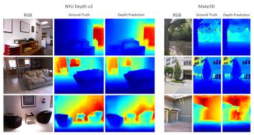
Deep Depth from Defocus: how can defocus blur improve 3D estimation using dense neural networks?
We also investigate the influence of blur on depth prediction observing model uncertainty with a Bayesian neural network approach.
Generative Adversarial Networks for Realistic Synthesis of Hyperspectral Samples
This work addresses the scarcity of annotated hyperspectral data required to train deep neural networks.

Beyond RGB: Very High Resolution Urban Remote Sensing With Multimodal Deep Networks
In this work, we investigate various methods to deal with semantic labeling of very high resolution multi-modal remote sensing data.
Joint Learning from Earth Observation and OpenStreetMap Data to Get Faster Better Semantic Maps
In this work, we investigate the use of OpenStreetMap data for semantic labeling of Earth Observation images.
Fusion of Heterogeneous Data in Convolutional Networks for Urban Semantic Labeling (Invited Paper)
We introduce residual correction as a way to learn how to fuse predictions coming out of a dual stream architecture.
Semantic Segmentation of Earth Observation Data Using Multimodal and Multi-scale Deep Networks
This work investigates the use of deep fully convolutional neural networks (DFCNN) for pixel-wise scene labeling of Earth Observation images.
On the usability of deep networks for object-based image analysis
In this work, we show how to use such deep networks to detect, segment and classify different varieties of wheeled vehicles in aerial images from the ISPRS Potsdam dataset.
How Useful is Region-based Classification of Remote Sensing Images in a Deep Learning Framework?
In this paper, we investigate the impact of segmentation algorithms as a preprocessing step for classification of remote sensing images in a deep learning framework.
